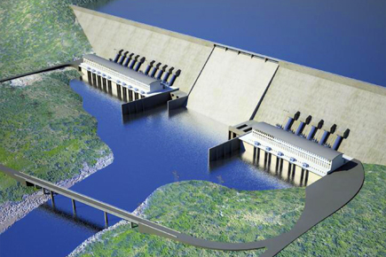
A rendering of the Grand Renaissance Dam under construction in Ethiopia on the Blue Nile. Its completion is expected to profoundly change the allocation of water resources in Africa.
Egypt and Sudan are utterly dependent on the waters of the Nile River. Over the past century both of these desert countries have built several dams and reservoirs, hoping to limit the ravages of droughts and floods which have so defined their histories. Now Ethiopia, one of eight upriver states and the source of most of the Nile waters, is building the largest dam in Africa. Located on the Blue Nile twenty five miles from the Ethiopian border with Sudan, the Grand Renaissance Dam begins a new chapter in the long, bellicose history of debate on the ownership of the Nile waters, and its effects for the entire region could be profound.
For more on the recent history of Africa, please see these articles on Politics in Senegal, the Darfur Conflict, Piracy in Somalia, Violence and Politics in Kenya, Women in Zimbabwe, and Sport in South Africa.
On water and environmental issues, readers may also want to see these Origins articles: World Water Crisis; The Changing Arctic; Climate Change and Human Population; Global Food Crisis; and Over-Fishing.
In the fall of 2012 newspapers around the world reported on a Wikileaks document, surreptitiously acquired from Stratfor, the Texas security company, revealing Egyptian and Sudanese plans to build an airstrip for bombing a dam in the Blue Nile River Gorge in Ethiopia. The Egyptian and Sudanese governments denied the reports.
Whether or not there were such plans in 2012, there is a long history of threats and conflicts in the Nile River Basin. Downriver Egypt and Sudan argue that they have historic rights to the water upon which they absolutely depend—and in 1979 Egyptian President Anwar Sadat threatened war on violators of what he saw as his country’s rights to Nile waters. Upriver Ethiopia, Kenya, Uganda, Rwanda, Burundi, and Tanzania argue that they too need the water that originates on their lands.
Since the twelfth century C.E. Christian Ethiopian kings have warned Muslim Egyptian sultans of their power to divert waters of the Nile, often in response to religious conflicts. But these were hypothetical threats.
Today, however, Ethiopia is building the Grand Renaissance Dam and, with it, Ethiopia will physically control the Blue Nile Gorge—the primary source of most of the Nile waters.
The stakes could not be higher for the new leaders in Egypt and Ethiopia, President Mohamed Morsi and Prime Minister Hailemariam Desalegn, as well as Sudan’s long-time President, Omar El Bashir. The stakes are perhaps even higher for the millions of people who owe their livelihood and very existence to the Nile’s waters.
Egypt and the Nile
The Nile has been essential for civilization in Egypt and Sudan. Without that water, there would have been no food, no people, no state, and no monuments. As Herodutus famously wrote in the 5th century B.C.E., “Egypt is the gift of the Nile.”
For millennia peoples have travelled along the banks of the Nile and its tributaries. Scores of ethnic groups in Egypt, Ethiopia, and Sudan share architecture and engineering, ideas and traditions of religion and political organization, languages and alphabets, food and agricultural practices.
In 3000 B.C.E., when the first Egyptian dynasty unified the lower and upper parts of the Nile River, there were no states in Eastern or Central Africa to challenge Egypt’s access to Nile waters.
The Nile was a mysterious god: sometimes beneficent, sometimes vengeful. Floods between June and September, the months of peak flow, could wipe out entire villages, drowning thousands of people. Floods also brought the brown silt that nourished the delta, one of the world’s most productive agricultural regions, feeding not only Egypt but many of its neighbors.
The river’s central importance to Egyptian life is captured in A Hymn to the Nile, recorded in Papyrus Sallier II:
Hail to thee, O Nile, that issues from the earth and comes to keep Egypt alive! …
He that waters the meadows which He created …
He that makes to drink the desert …
He who makes barley and brings emmer into being …
He who brings grass into being for the cattle …
He who makes every beloved tree to grow …
O, Nile, verdant art thou, who makes man and cattle to live.
The Nile’s seasonal flooding is a central theme in Egyptian history. The river flow follows regular patterns, increasing between May 17 and July 6, peaking in September, and then receding until the next year. But the river volume is very unpredictable, as documented by nilometers (multi-storied structures built in the river to measure water heights). Successive empires of Pharaohs, Greeks, Romans, Christian Copts, and Muslims celebrated the rising waters of the Nile and dreaded floods or droughts.
Five millennia of Nile history show how years with high water have produced ample food, population growth, and magnificent monuments, as during the first five dynasties from 3050 B.C.E. to 2480 B.C.E. Periods with low water have brought famine and disorder. The Book of Genesis describes seven years of famine that historians associate with the drought of 1740 B.C.E.
From the time of the Pharaohs until 1800 C.E., Egypt’s population rose and fell between 2 to 5 million, due to food availability and epidemics. The irrigation projects of the 19th century Ottoman ruler Mohammad Ali allowed year-around cultivation, causing population growth from 4 to 10 million. Since the opening of the Aswan High Dam in 1971, Egypt’s population has increased from about 30 to 83 million.
The Sources of the Nile
Despite the extraordinary importance of the Nile to people downstream, the origin of the great river was a mystery until the middle twentieth century. Herodotus speculated that the Nile arose between the peaks of Crophi and Mophi, south of the first cataract. In 140 C.E. Ptolemy suggested the source was the Mountains of the Moon, in what are now called the Ruwenzori Mountains in Uganda.
The 11th century Arab geographer al-Bakri postulated West African origins, confusing the Niger River, which empties into the Atlantic Ocean, with the Nile River. In 1770 the Scottish explorer James Bruce claimed his discovery of the source in Ethiopia, while in 1862 John Hanning Speke thought he found it in Lake Victoria and the equatorial lakes.
The river’s limited navigability only increased its mystery. The Blue Nile River descends 4501 feet in 560 miles from Lake Tana in the Ethiopian highlands through a deep gorge with crocodiles, hippopotamuses, and bandits to the Sudan border and the savannah. Despite the efforts of scores of intrepid adventurers, the Blue Nile in Ethiopia was not successfully navigated until 1968 by a team of British and Ethiopian soldiers and civilians equipped by the Royal Military College of Science.
Further south up the White Nile in the lakes and rivers of Burundi, Rwanda, Kenya, Tanzania, and Uganda, the Egyptian cultural influence is less pronounced, due to the Sudd, a gigantic and impassable swamp which absorbs waters from the equatorial lake tributaries. The Nile River historian Robert O. Collins reports that “no one passed through this primordial bog” until 1841.
Not until the 20th century did it become clear that the Nile is part of a vast river system with dozens of tributaries, streams, and lakes, stretching from the Mediterranean Sea to the remote mountains of Burundi, in tropical central Africa, and to the highlands of Ethiopia, in the Horn of Africa.
Spanning more than 4,200 miles, it is the longest river in the world. It has also become clear that the volume of water which flows through the Nile is relatively small—a mere two percent in volume of the Amazon’s and fifteen percent of the Mississippi—and mostly (86%) from Ethiopia.
Ethiopia, Egypt, and the Historical Struggle for the Nile’s Waters
Ethiopia and Egypt have had a long relationship of both harmony and discord, the latter the result of religious issues and access to Nile water, among other factors.
Ethiopia’s first well documented government was in Aksum, a city-state that controlled a large empire from the Ethiopian highlands across the Red Sea to Yemen. From 100 until 800 C.E. Aksumites participated in Mediterranean and Indian Ocean trade.
The cultural relationship between Egypt and Ethiopia was institutionalized when the Aksumite King Ezana converted to Christianity in 330 C.E. For 16 centuries (until 1959) the Egyptian bishop of the Ethiopian Orthodox Church was appointed by the Egyptian patriarch in Alexandria, often under the influence of the Egyptian government.
Ethiopians were profoundly influenced by the Middle East, even writing their state and geography into Bible stories. The source of the Blue Nile became the Gihon, one of the four rivers that flowed from the Garden of Eden. The 14th century C.E. myth of national origins connected Ethiopia’s rulers to the Old Testament. In this legend the Queen of Sheba (Mekedda), journeyed north from Ethiopia to Jerusalem to meet King Solomon in 900 B.C.E. A romantic relationship produced a child, Menelik I, the first in Ethiopia’s Solomonic Dynasty.
When Menelik became an adult, despite his father’s wish that he become the next King of Israel, he escaped to Ethiopia with the Ark of the Covenant—the cabinet which contained the tablets of the ten commandments given by God to Moses on Mount Sinai. Menelik stored the Ark on an island in Lake Tana—into which the Gihon flows—before it was moved to Aksum, where many Ethiopians believe the Ark remains to this day. Another Ethiopian legend is that Mary and Jesus stayed a night on that same island (Tana Cherquos) during their flight from the Holy Land to Egypt.
The Muslim conquest of Egypt in 640 C.E. put Christian Ethiopia in a defensive position. Because the Ethiopian Orthodox Church remained subordinate to the Orthodox Church in Alexandria, and Egypt had become a Muslim country, Ethiopians became suspicious and resentful of the control Egypt had on the appointment of their Christian bishop (abun). Muslim Egyptians also controlled Jerusalem and had the power to expel Ethiopian pilgrims to their holiest of cities.
So Ethiopians began to claim power over Egypt through control of the Nile. During the Crusades the Ethiopian emperor Lalibela (1190-1225)—who built a new Jerusalem in Ethiopia, safe from Muslim occupation in magnificent, underground rock-hewn churches—threatened retribution by diverting the Tekeze River from its pathway north into Sudan (where it becomes the Atbara and then joins the Nile).
The first Egyptian to write about the potential for an Ethiopian diversion of the Nile was the 13th century Coptic scholar Jurjis al-Makin (d. 1273).
Stories about Ethiopia’s power over the Nile inspired the 14th century European legend of Prester John, a wealthy Christian Ethiopian priest king. In 1510 the legend returned to Ethiopia with Portuguese explorer Alfonso d’ Albuquerque, who considered the possibility of destroying Egypt by diverting the Nile to the Red Sea. In 1513 d’Albuquerque even asked the Portuguese king for workers skilled in digging tunnels. Nothing came of the plan.
But conflict between Egypt and Ethiopia continued, often as proxy wars between Christians and Muslims on Ethiopia’s northern or southeastern borderlands. The sixteenth century invasion of Ethiopia by Ahmad Gragn, the Muslim imam from the Adal Sultante, was seen as an Egyptian conflict.
In the nineteenth century Egypt and Ethiopia fought over control of the Red Sea and upper Nile Basin. The climax came in 1876 at the Battle of Gura in present day Eritrea where the Ethiopians delivered a humiliating defeat to the Egyptian army.
Colonial-Era Conflicts over the Nile
The European partition of Africa in the 1880s added huge complexity to this conflict.
Egypt was colonized by England in 1882. Ethiopia defeated the Italians at the Battle of Adwa in 1896 becoming the only African country to retain its independence during the “scramble for Africa.” But colonization created many new states in the Nile Basin (Eritrea, Uganda, Rwanda, Burundi, Kenya, and Tanganika) and set off new competition for resources and territory.
Egypt was prized for the Nile Delta, a region of unsurpassed agricultural productivity. After the completion of the Suez Canal in 1869, Egypt also offered access to the Red Sea and the Indian Ocean. For the British control of Egypt meant more profitable trade with India, its richest colony. For the French, the canal offered quicker access to Indochina, its most lucrative colony.
In the late nineteenth century, since controlling Egypt was the key to Asian wealth, and since Egypt depended on the Nile, controlling the source of the Nile became a major colonial goal.
The French-English competition for control of the Nile Basin climaxed in 1898 at Fashoda.
The French conceived of the idea of building a dam on the White Nile, so as to undermine British influence further downriver and establish east-west control of the continent. They organized a stupendous pincer movement with one group of soldiers traveling from East Africa across Ethiopia and the other from West Africa across the Congo.
The British heard of the French expedition, and, having just captured Khartoum ordered a fleet of gun boats and steamers with soldiers under the leadership of General Horatio Herbert Kitchener upriver to Fashoda, the site of the proposed dam. With fewer than 200 men, the French were embarrassed. In 1899 the two colonial powers reached an agreement which designated to France the frontiers of the Congo River and to England the frontiers of the White Nile.
The Fashoda Incident revealed how little Europeans understood about the Nile River. Thinking that most of the Nile waters came from the equatorial lakes (Victoria, Albert, Kyoga, and Edward), the English spent enormous energy on plans to increase White Nile water flows.
First called the Garstin Cut and later the Jonglei Canal, the British intended to create a channel that would maximize water transfer through the great swamp (where half of it evaporated).
One of the most expensive engineering projects in Africa, it was terminated in 1984 by the Sudan People’s Liberation Army, because of the severe disruption it brought to the lives of the indigenous upper Nile peoples. If the 300 mile-long Jonglei Canal had been completed, it would have increased water flows by nearly 4 billion cubic meters into the White Nile.
Negotiating the Nile: Treaties and Agreements over the Nile Waters
Treaty negotiations about Nile waters started during the colonial era as England tried to maximize agricultural productivity in the delta.
In 1902 the British secured from the Ethiopian Emperor Menelik II an agreement to consult with them on any Blue Nile water projects, especially on Lake Tana. As the controlling imperial power in East Africa, agreements with Kenya, Tanganika, Sudan, and Uganda were pro forma, internal colonial matters.
After achieving its independence in 1922, Egypt negotiated the Nile Waters Agreement of 1929 with the East African British colonies. This accord established Egypt’s right to 48 billion cubic meters of water flow, all dry season waters, and veto-power over any upriver water management projects; newly independent Sudan (1956) was accorded rights to 4 billion cubic meters of water. The Ethiopian monarch was not consulted—at least in part because no one understood how much Nile water actually came from Ethiopia.
The 1959 Nile Waters Agreement between Egypt and Sudan was completed before all the upriver states achieved independence: Tanganika (1961), Uganda (1962), Rwanda (1962), Burundi (1962), and Kenya (1963).
The signatories of the 1959 Agreement allocated Egypt 55.5 billion cubic meters of water annually while Sudan was allowed 18.5 billion cubic meters. These 79 billion cubic meters represented 99% of the calculated average annual river flow.
The treaty also allowed for the construction of the Aswan High Dam (completed in 1971), the Roseires Dam (completed 1966 on the Blue Nile in Sudan), and the Khashm al-Girba Dam (completed in 1964 on the Atbara River in Sudan).
The treaty so negatively affected the upriver states that it provided the inspiration for the Nyerere Doctrine, named after independent Tanzania’s first president, which asserted that former colonies had no obligation to abide by treaties signed for them by Great Britain.
Emperor Haile Selassie was offended by President Nasser’s exclusion of Ethiopia in the Nile Waters Agreement and in planning for building the Aswan Dam. He negotiated the 1959 divorce of the Ethiopian Orthodox Church from the Orthodox Church in Alexandria, ending 1600 years of institutional marriage.
He also began planning for several dams on the Blue Nile and its tributaries, contributing $10 million dollars from the Ethiopian treasury towards a study by the U.S. Department of Reclamation resulting in a seventeen volume report completed in 1964 and titled Land and Water Resources of the Blue Nile Basin: Ethiopia.
Nasser responded by encouraging Muslims in Eritrea (reunified with Ethiopia after World War II) to secede from Ethiopia. He also encouraged Muslim Somalis to fight for the liberation of Ethiopia’s Ogaden region.
Ethiopia won the war with Somalia in 1977-78 and retained the Ogaden. Its 30 year war with Eritrea, an Egyptian ally, came at a tremendous cost. Haile Selassie was overthrown in 1974, and after 1993 Eritrea won independence and Ethiopia became a landlocked country—although it still possessed the headwaters of the Blue Nile.
In the middle of the 1980s, rains failed in the Ethiopian highlands, causing a serious water crisis upriver and downriver. One million Ethiopians died as a result of drought and famine—made worse by Civil War with Eritrea. Egypt averted disaster but Aswan’s turbines were nearly shut down, creating an electric power nightmare; and crops failed in the delta, bringing the real prospect of famine.
As a result, Egyptians came to understand that their great Aswan Dam had not solved their historic dependency on upriver Nile water. In 1987, after years of hostile rhetoric, the Egyptian President Hosni Mubarak and the Ethiopian President Haile Mariam Mengistu replaced the language of threat and confrontation with words of conciliation and cooperation.
Then in the 1990s the Ethiopian rains returned and, remarkably, Hosni Mubarak redoubled efforts begun during the Sadat administration to build the Toshka Canal, one of the world’s most expensive and ambitious irrigation projects. This plan would take 10% of waters in Lake Nasser to irrigate Egypt’s sandy Western Desert, increasing Egypt’s need for Nile water even if they maintained their 1959 treaty share of 55 billion cubic meters.
In anger and disbelief, the Ethiopian Prime Minister Meles Zenawi protested: “While Egypt is taking the Nile water to transform the Sahara Desert into something green, we in Ethiopia—who are the source of 85% of that water—are denied the possibility of using it to feed ourselves.”
He then began plans for the Grand Renaissance Dam.
International water law has not resolved differences about ownership of Nile Waters. The Helsinki Agreement of 1966 proposed the idea of “equitable shares”—and the idea was taken up again in the 1997 United Nations Convention on the Law of Non-Navigational Uses of International Watercourses.
A proposal for “equitable shares” was again put forward in the 1999 Nile Basin Initiative, which included all the affected countries. Unfortunately the initiative did not resolve the conflict between Egypt and Sudan’s claims of historic rights and the upper river states’ claims for equitable shares.
In 2010, six upstream countries (Ethiopia, Kenya, Uganda, Rwanda, Burundi, and Tanzania) signed a Cooperative Framework Agreement seeking more water shares. Egypt and Sudan rejected the agreement because it challenged their historic water rights.
Ethiopia and the Lessons of Dam Building
One lesson from the last century of mega-dam building is that upriver countries have the most power when negotiating water rights. The first of the mega-dams, the Hoover Dam on the Colorado River in the United States, cost Mexico water. The Ataturk Dam in Turkey has had a devastating impact on downriver Syria and Iraq. China and Tibet control waters on multiple rivers flowing downstream to India, Pakistan, Myanmar, Bangladesh, and Vietnam.
Another lesson is that mega-dams have enormous and unanticipated environmental impacts. The Aswan High Dam has disrupted the ecosystems of the river, the delta, and the Mediterranean with results of reduced agricultural productivity and fish stocks. It also caused a series of seismic events due to the extreme weight of the water in Lake Nasser, one of the world’s largest reservoirs.
Although late to mega-dam building, Ethiopia is now making up for lost time. One of the tallest dams in the world was completed in 2009 on the Tekeze River in northern Ethiopia. Three major dams on the Omo and Gibe Rivers in southern Ethiopia are either completed or nearly so.
The biggest of Ethiopia’s water projects, the Grand Renaissance Dam, will have a reservoir holding 67 billion cubic meters of water—twice the water held in Lake Tana, Ethiopia’s largest lake—and is expected to generate 6000 megawatts of electricity.
Ethiopians hope these water projects—which extend to 2035 with other Nile tributaries and river systems—will lift their country out of poverty. Similar large dams have produced economic miracles in the United States, Canada, China, Turkey, India, Brazil, and, of course, Egypt.
Ethiopia’s options for economic development are limited. With nearly 90 million people it is the most populous landlocked country in the world. It is also one of the world’s poorest countries—174 on the list of 187 countries in the United Nations Human Development Index for 2012. (Sudan is 169 and Egypt 113.) This index rates countries based on life expectancy, education, and income, among other criteria.
Part of Ethiopia’s challenge is that 85 percent of the workforce is in agricultural commodities that bring low profits. Ethiopia is already leasing land in its southern regions to Saudi Arabia, India, and China for large irrigated water projects—despite severe land shortage in its northern regions—because it does not have the funds to develop this land on its own.
If Ethiopia cannot use its elevation and seasonal rains for hydro-electric power and irrigation, what is it to do?
The Grand Renaissance Dam
The state-owned Ethiopian Electric Power Corporation optimistically reports that the Grand Renaissance Dam will be completed in 2015 at a cost of nearly 5 billion dollars. As of 2013, the project is 13% complete, suggesting that it may be many years and billions of dollars before the dam is finished. The Tekeze dam was well over its predicted budget and years behind schedule.
The major obstacle to completion is financing.
The World Bank, the European Investment Bank, the Chinese Import-Export Bank, and the African Development Bank provided financing for some of the other dams; but concerns about the environmental and political impact of this latest dam have discouraged lenders.
The International Monetary Fund suggested that Ethiopia put the dam on a slow track, arguing that the project will absorb 10% of Ethiopia’s Gross Domestic Product, thus displacing other necessary infrastructure development.
Nevertheless the Ethiopian government insists that it will stick with its schedule and finance the project domestically. It probably will secure more help from China, a loyal ally and the world’s major developer of hydroelectric power.
The Ethiopians argue that the Grand Renaissance Dam could be good for everyone. They contend that storing water in the deep Blue Nile Gorge would reduce evaporation, increasing water flows downstream.
The Ethiopians also argue that the new dam will be a source of hydroelectric power for the entire region and will manage flood control at a critical juncture where the Nile Gorge descends from the Ethiopian highlands to the Sahel, thus reducing risk of flooding and siltation, extending the life of the dams below stream.
Egypt and Sudan are understandably concerned about Ethiopia’s power over Nile waters. What happens while the reservoir behind the Grand Renaissance Dam is filling up, when water flow may be reduced 25 % for three years or more? After the reservoir is filled what will happen when rains fail in the Ethiopian highlands? Who will get the water first?
If the question of Nile waters was sensitive in the centuries before 1900, when Ethiopia and Egypt each had populations of 10 million or less, what will happen over the next twenty years, as their populations each surpass 100 million and the collective population of the Nile River Basin countries reaches 600 million?
The Grand Renaissance Dam poses a question as basic as water itself: Who owns the Nile? When the Grand Renaissance Dam closes its gates on the Blue Nile River, whether it is in 2015 or 2025, the time for a final reckoning will have arrived.
Ethiopia will then have the power to claim its water shares, with the backing of all the upriver states. Egypt and Sudan’s claims to historic water rights will have become merely hypothetical. In the context of a difficult history, violence is a possibility, but good solutions for all can be achieved through diplomacy and leadership.
Collins, Robert O. The Nile. New Haven and London: Yale University Press, 2002.
Erlich, Haggai. The Cross and the River: Ethiopia, Egypt, and the Nile. Boulder and London: Lynn Rienner Publishers, 2002.
Henze, Paul B. Layers of Time: A History of Ethiopia. New York: Palgrave Macmillan, 2000.
Solomon, Steven. Water: The Epic Struggle for Wealth, Power, and Civilization. New York: HarperCollins, 2010.
Tignor, Robert L. Egypt: A Short History. Princeton and Oxford: Princeton University Press, 2010.