
California's 23rd district segments Democratic voters along the coastline.
Source: nationalatlas.gov
 concentration of Columbus, Ohio, located at the center of the map in Franklin County, is split into thirds, each segment then attached to—and outnumbered by—largely conservative suburbs.")
The urban (and mostly liberal) concentration of Columbus, Ohio, located at the center of the map in Franklin County, is split into thirds, each segment then attached to—and outnumbered by—largely conservative suburbs.

North Carolina's 12th congressional district is predominantly African-American and liberal.
Source: nationalatlas.gov

Illinois's 4th congressional district includes two Hispanic areas while remaining contiguous by narrowly tracing Interstate 294.
Source: nationalatlas.gov
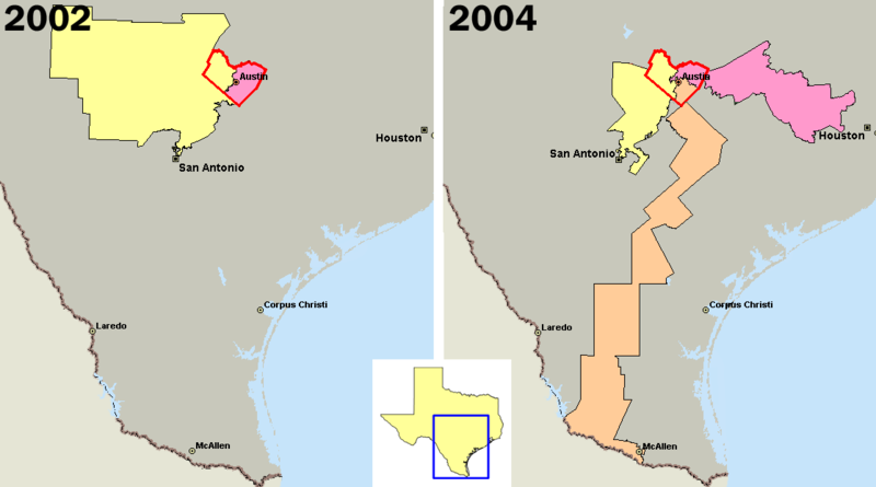
U.S. congressional districts covering Travis County, Texas (outlined in red). In 2003, the majority of Republicans in the Texas legislature redistricted the state, diluting the voting power of the heavily Democratic county by parcelling its residents out
Source: Wikimedia Commons

Allocation of congressional seats after the 2010 census
Source: U.S. Census Bureau

At top: Congressional districts by their representative's political party: At bottom: political party affiliation change since the 111th Congress, which ran from January 2009 to January 2011.
Source: nationalatlas.gov
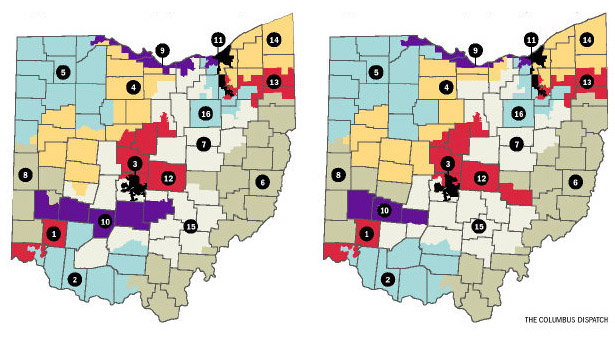
Congressional districts proposed in Ohio in September, left, and on December 14, right.
Source: Columbus Dispatch